

2023/08/29 10:21 Weather News
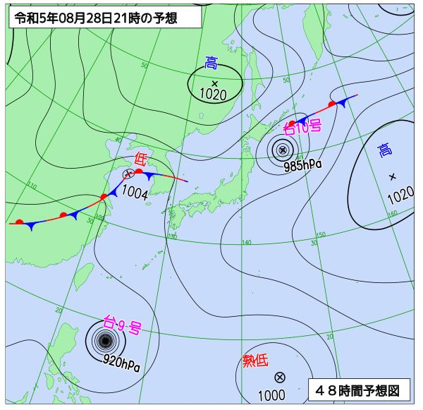
Of the three typhoons, Typhoon No. 11, which occurred yesterday (Monday) on the 28th, is expected to have the greatest impact. It is expected to move west-northwest as it develops and approach Okinawa in early September.
Typhoon No. 9 is expected to pass between the Philippines and Taiwan, and it is expected to have indirect impacts such as high waves on the Sakishima Islands. Typhoon No. 10 is expected to leave Japan quickly and turn into an extratropical cyclone tonight.
» Latest typhoon information
Typhoon No. 11 develops and approaches Okinawa in early September
Central location East of the Philippines
Size class //
Strength class //
Travel West 25 km/h
Central pressure 996 hPa
Maximum wind speed 20 m/s (near center)
Maximum instantaneous wind speed 30 m/s
Typhoon No. 11 is expected to gradually intensify as it travels through areas with high sea surface temperature and small vertical wind shear (differences in wind direction and speed above the sea surface). The maximum wind speed near the center will reach 25m/s on Thursday, September 31, the day after tomorrow, and a strong wind area is expected on Friday, September 1, when it approaches Okinawa.
In Okinawa, wind and rain are expected to intensify due to the approach of the typhoon, and stormy weather is expected. Early typhoon countermeasures are required. Depending on the course, moist warm air may flow into the Pacific side of western Japan, causing localized heavy rain.
» Radar Wind Mode (Windflow)
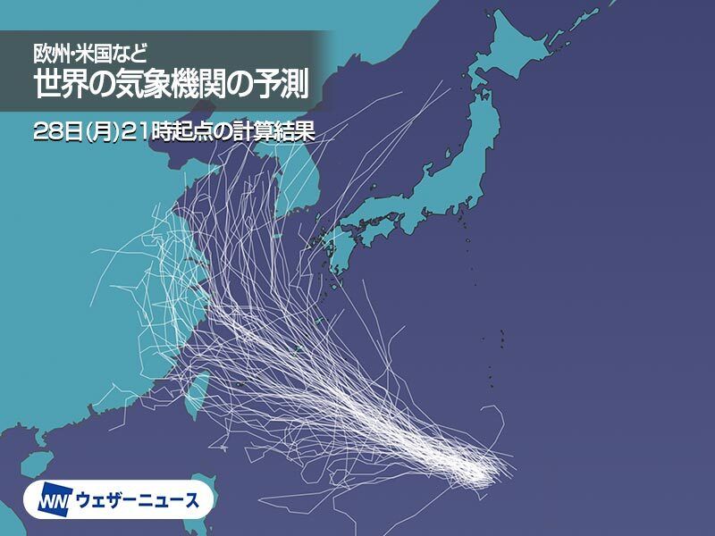
Possible paths are still predictable
Since the Pacific High is strengthening from the east of Japan, most of the members tend to move northwest. After that, there are quite a wide range of routes, such as those heading for the East China Sea through Okinawa, those heading for the Chinese continent, those aiming for the Sea of Japan, and those heading south such as Taiwan instead of Okinawa. Masu.
Not only the course, but also the timing and power predictions are in a situation where the error is quite large. The error is expected to shrink as the days go by, so please pay attention to future information.
Probability of entering the storm zone of a typhoon
Prefectural forecast areas with a probability of 3% or more to enter the storm area of Typhoon No. 11 within 5 days are as follows. (Japan Meteorological Agency)
Nagasaki Prefecture
Goto 3%
Amami region 35 %
Okinawa main island region
Main Island North/Central South 41 %
Kerama and Aguni Islands 44 %
Kumejima 41 %
Daito Island 9%
Miyakojima region 22 %
Yaeyama region
Ishigaki Island 13%
Yonaguni Island 7%
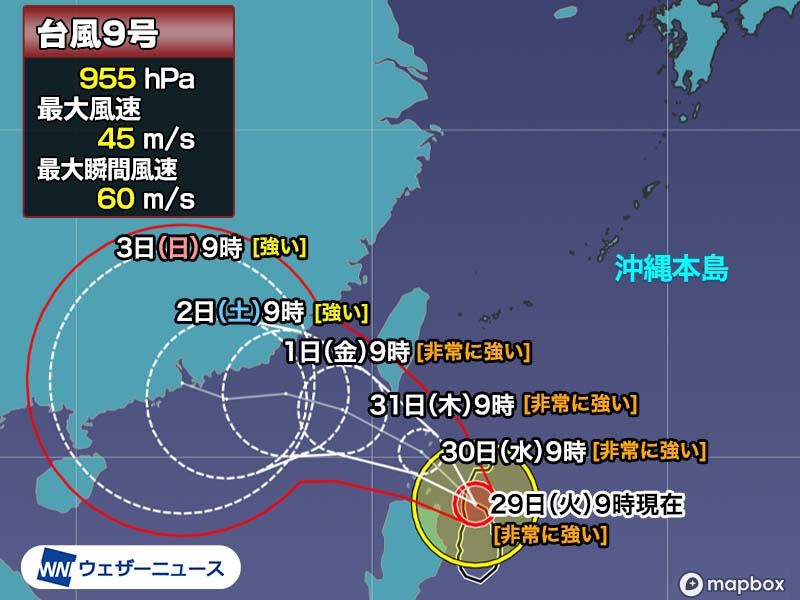
Typhoon No. 9 Sakishima Islands, watch out for high waves and swells
Central location East of the Philippines
Size class //
Strength class Very strong
move northwest slowly
Central pressure 955 hPa
Maximum wind speed 45 m/s (near center)
Maximum instantaneous wind speed 60 m/s
Typhoon No. 9 is moving slowly northwest over the seas east of the Philippines. It is expected to move westward and pass south of Taiwan while maintaining a very strong intensity. The tsunami will pass far away from the Sakishima Islands, so it is unlikely to have a direct impact.
However, since it is a very strong force, the waves will be high on the sea, and we need to be careful of high waves and swells after tomorrow, the 30th (Wednesday).
Typhoon No. 10 will move away from Japan in the future

Central location East of Japan
Size class //
Strength class //
Moving East 40 km/h
Central pressure 990 hPa
Maximum wind speed 23 m/s (near center)
Maximum instantaneous wind speed 35 m/s
Typhoon No. 10 is expected to move eastward over the eastern seas of Japan and move further away from the Japanese archipelago. It is expected to turn into an extratropical cyclone tonight.
In the coastal areas of Hokkaido and Tohoku, the effects of high waves such as swells remain after the typhoon leaves, so please be careful.
» Radar Wind Mode (Windflow)
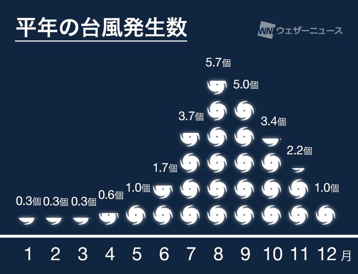
The fourth typhoon occurred in August this year
The average number of typhoons in August is 5.7, which is the time of the year with the most typhoons. The number of typhoons this year is slightly lower than usual, but Weathernews forecasts that there will be at least 10 more typhoons by the end of the year.
As autumn approaches, it is expected that the number of typhoons that affect the Honshu area will increase, so please prepare for typhoons and heavy rains in preparation for the coming season.
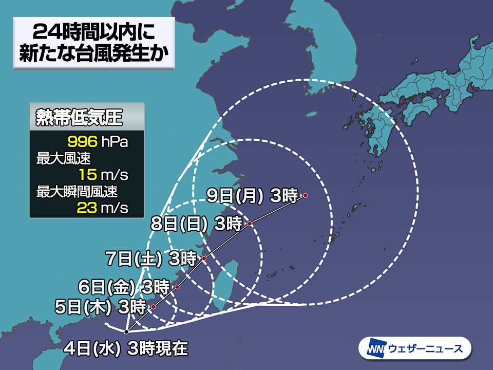
A new typhoon No. 11 occurs
It is expected to move westward and approach the vicinity of Okinawa. At 9:00 on September 1st (Friday), the center is in the south of Okinawa, the central pressure is 980hPa, and the maximum wind speed near the center is expected to be 30m/s.
Depending on its course after that, it may have an impact on Japan, but there is still an error in the forecast. The error is expected to shrink as the days go by, so please pay attention to future information.
» Radar Satellite Cloud Image Mode
typhoon name
The name of Typhoon No. 9, “Saola,” was proposed by Vietnam, and refers to an animal called the Vietnamese antelope. Typhoon No. 10’s name “Damrey” was proposed by Cambodia and is derived from the Khmer word for “elephant”. The name of Typhoon No. 11, “Haikui,” was proposed by China and comes from the Chinese word for “sea anemone.”
» Radar Typhoon Mode
Reference materials, etc.
Meteorological Satellite Visible Image: NICT-National Institute of Information and Communications Technology
Tags: Typhoon cautious typhoons expected approach Okinawa early September Weather News


